WELCOME TO THE DINAMIS WEBSITE
DINAMIS—the French national facility for institutional procurement of VHR satellite imagery—is a platform that acquires and distributes satellite Earth imagery for French and foreign institutional users under specific subscription conditions.
The platform aims to further institutional uptake of satellite data for programmes in the public interest in fields such as the environment, education and development of innovative services for:
• Research and development: fundamental and applied research, early-stage development and demonstration phases
• Land management and planning
• Environmental monitoring and management
• Innovative products & services
DINAMIS provides access to a bouquet of very-high-resolution commercial optical satellite data and its associated services.
News
DINAMIS Catalog Version 02 is Now Live!
This major upgrade represents a significant milestone in our commitment to enhancing your user experience by delivering expanded services through a simplified and modernized interface. A Unified and Intuitive Interface […]
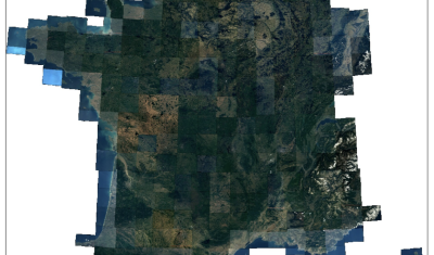
Spot 6-7 | Metropolitan France Coverage 2025 – Completed
DINAMIS is pleased to announce the completion of the 2025 Metropolitan France coverage at very high spatial resolution by the Spot 6 satellite (acquired between March 1, 2025, and October 12, 2025). […]
DINAMIS at Cambodia Geospatial Day 2025
Cambodia Geospatial Day was held on Tuesday, November 18, 2025, at the Institute of Technology of Cambodia (ITC) in Phnom Penh. Organized by the Khmer Earth Observation Laboratory Kheobs and the Espace-Dev Joint Research Unit […]