
Geometric processing
Primary products
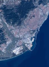
The Primary product is the geometric processing level closest to the natural image acquired by the sensor. This product restores perfect collection conditions: the sensor is placed in rectilinear geometry, and the image is clear of all radiometric distortion. This product is optimal for those users familiar with satellite imagery processing techniques who want to apply their own production methods (orthorectification or 3D modelling for example). To this end, RPCs and the sensor model are provided with the product to ensure full autonomy and simplicity for users. The Primary level product is in sensor geometry, synthesized on a perfect single and linear push-broom array with an equalized radiometry on the native dynamic range of the sensor, 12 bits (4096 values).
Ortho images
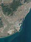
The Ortho product is a georeferenced image in Earth geometry, corrected from acquisition and terrain off-nadir effects. The Ortho is produced as a standard, with fully automatic processing
The standard Ortho product is an image that has been corrected (viewing angle and ground effects) so that it can be superimposed on a map. In addition to radiometric and geometric adjustments, a geometric process using a relief model (known as orthorectification) eliminates the perspective effect on the ground (not on buildings), restoring the geometry of a vertical shot. The Ortho product is optimal for simple and direct use of the image. It can be used and ingested directly into a Geographic Information System. This processing level facilitates the management of several layers of products, from the same sensor or others, while reducing localization gaps that can be caused by different viewing angles or relief between the various layers.
The standard 3D model used for ground corrections is the worldwide Reference3D dataset, which is part of Airbus DS Elevation30 suite.
Radiometric processing level
Basic imagery corresponds to raw data without any radiometric processing. Each pixel is given in digital numbers (DN), i.e. native pixel values from the sensor acquisition (after equalisation). Those digital numbers quantify the energy recorded by the detector, corrected relative to the other detectors to avoid non-uniformity noise.
Key benefits
• Perfect for expert users addicted to pure data and familiar with satellite imagery applications and image processing tools.
• Ideal to carry up calibration and own spectral analysis.
Reflectance
Reflectance imagery is radiometrically corrected from sensor calibration and systematic atmospheric effects of the atmosphere (molecular or ‘Rayleigh’ diffusion). Cloud, cloud veil, haze, aerosol (pollution, sand wind) remain. Image values are provided in normalised reflectance values with a 1/10,000 ratio. In clear sky conditions (no dynamic factors affecting the low atmosphere as veils), the reflectance value is directly assimilated to the ground surface reflectance.
Reflectance is more straightforward and easier to use than Basic radiometric processing. Such benefits are, for example, on spectral and monitoring analysis to ensure direct comparison between images at different dates or different calibrated sensors and on image processing to correct the bluish effects from atmosphere to achieve reliable true colour.
Key benefits :
• Corrects the bluish effects from atmosphere, so that colours are reliable and true.
• Ensures better stability of luminosity/contrast on screen.n
• Prepares end users for seamless coverage (e.g. mosaicking).
Display
Display products are generated on a new algorithm based on the Reflectance product.
In the Display radiometric option, a true colour curve has been applied to the image directly usable for visualization on screen. The colour curve is the LUT (Look Up Table) computed by the Reflectance processing. The image true colour is properly retrieved from sensor calibration and correction of systematic effects of the atmosphere.Display processing is to be used when imagery needs to be immediately usable with optimised visual rend ering. The imagery values are 8-bit numbers optimised for a direct rendering on the screen. The values are not reversible to spectral physical unit.
Key benefits :
• Ideal radiometric processing level when imagery needs to be immediately usable with optimised visual rendering.
• Optimised for display on screens (8 bit).
Product and Image Format
Pléiades imagery is available in different product and image formats. Pléiades products are by default delivered in DIMAP V2. The image can be output in different raster formats, either GeoTIFF or JPEG 2000.
JPEG 2000 Optimised is intended for those looking for fast download and easy data sharing:
- 3.5 bits/pixel compression.
- Lossy compression: the compression rate is optimised to avoid any spatial effect but is not reversible.
- A spectral effect of 1/1000 is tolerated.
JPEG 2000 Regular is perfect for users who plan to do high precision post-processing:
- 8 bits/pixel compression.
- Lossless compression: the JPEG 2000 compression is completely reversible and does not include any effects in terms of information content.
Neither JPEG 2000 compression impacts on the imagequality. However, they do have a direct impact on file size with the Regular compression file size twice as large as the Optimised compression file size.
GeoTIFF is free of any compression (thestandard TIFF specification provides a simple JPEG compression scheme, which is unable to preserve the information content correctly). The file size is huge compared to JPEG 2000 because the GeoTIFF format stores integer values, encoded on the power of two: either8 or 16 bits. As Pléiades acquires images with a 12-bit depth, there is no benefit to the GeoTIFF 16-bit products storing 4 bits.
Encoded
• 12 bits : pixel value between 0 and 4096 (for each spectral band)
• 8 bits : pixel value between 0 and 256 (for each spectral band)
Projection
• Geographic: WGS84
• Cartographic : UTM WGS84
• Other on-request projections